Airports · Brokopondo
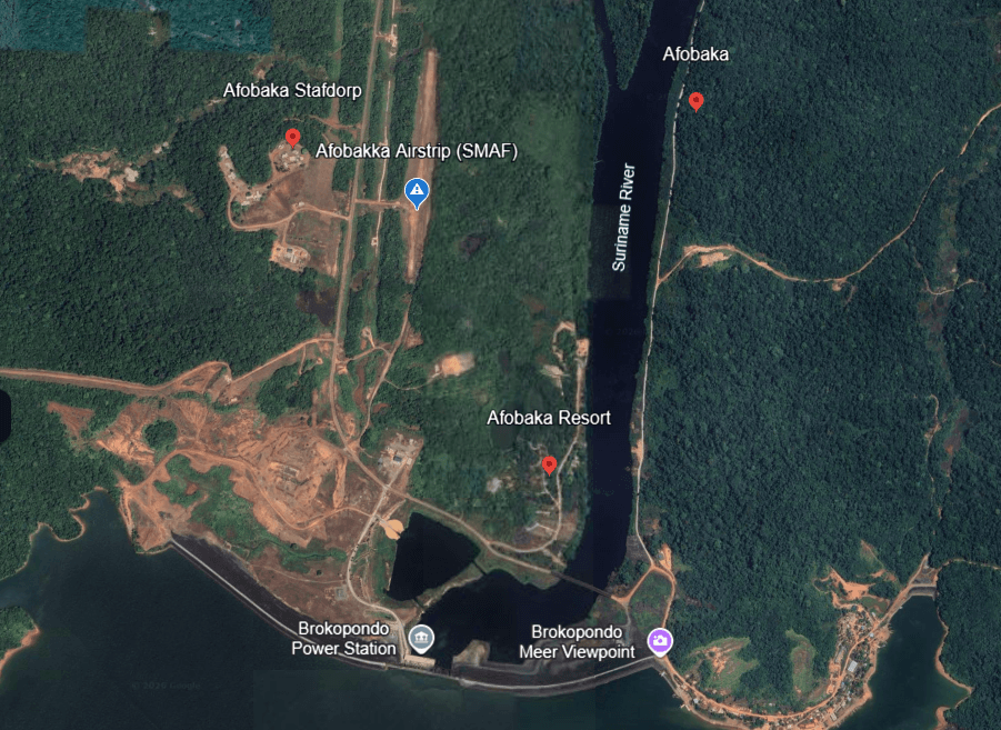
Afobakka Airstrip (SMAF)
Brokopondo
The airstrip consists of a single grass runway and serves the Afobaka region. It is strategically positioned between: Brokopondo Town Afobaka Dam Brokopondo Reservoir Mining operations in central Suriname The runway length is approximately 1.2 km (1,200 m) and has historically supported emergency, utility and mining-related aviation activities.
Local rules
Aviation access SMAF should be treated as a controlled aviation facility even if it has no permanent control tower. Obtain the current Suriname AIP entry, NOTAMs, weather, runway condition, operating hours, and permission requirements before departure. Confirm whether prior landing permission is required from Luchtvaartdienst/CADSUR, the aircraft operator, or another local authority. Verify runway length, grass condition, drainage, obstacles, wildlife activity, work in progress, and any temporary closure. Do not conduct night operations unless current official information confirms lighting, marking, authorization, and suitable procedures. Confirm aircraft performance for a grass runway at the actual temperature, aircraft weight, wind, and runway condition. Confirm whether fuel, parking, passenger facilities, baggage handling, security, and communications are available. Do not assume any of these services exist. Use a qualified local pilot or operator familiar with Suriname’s domestic strips and interior weather. Submit or maintain an appropriate flight plan and provide a reliable arrival/departure notification to the responsible authority and local receiving party. Community and land access Afobaka is not merely an aviation point; it is part of the Brokopondo interior and may involve nearby traditional communities, concession areas, mining operations, and private land. Before traveling overland or conducting fieldwork: Identify the local village authority, district authority, concession holder, or land manager. Introduce your team and state the purpose, dates, aircraft, passengers, equipment, and activities. Obtain permission before entering villages, photographing people, filming, interviewing, mapping, using drones, or visiting culturally sensitive areas. Respect local decisions, privacy, burial grounds, sacred places, ceremonies, hunting areas, and environmental restrictions. Obtain separate written authorization for mining, forestry, surveying, construction, research, tourism, commercial filming, or drone operations. Do not enter the Gross Rosebel mining area or use its airstrip without written authorization from the mine operator. Carry identification, passenger manifests, emergency contacts, first-aid supplies, communications equipment, drinking water, and a return/evacuation plan. Reconfirm access immediately before departure because permissions, runway conditions, security conditions, and local arrangements can change. These are prudent operating protocols, not a substitute for a current local permit or community decision. Recommended pre-flight checklist Before using SMAF, obtain written or recorded confirmation of: Current SMAF status from AIS/CADSUR. Valid NOTAMs and any runway works or closures. Permission from the responsible aviation authority/operator. Current runway length, surface condition, obstacles, and usable direction. Aircraft performance calculation for the grass runway. Weather and daylight limitations. Local ground transport and receiving contact. Medical and aircraft-evacuation plan. Police, fire, medical, and disaster contacts. Community, concession, or mining permissions relevant to the trip.
Nearest help
Police Brokopondo Police Station +597 324-002 +597 325-474 Approximately 7 km from the airstrip area. Brownsweg Police +597 680-1616 Regional police support. Medical Services Brokopondo Health Services The nearest established healthcare services are located in Brokopondo and Brownsweg. Medische Zending Brownsweg +597 711-8290 +597 877-0151
Last verified 2026-09-17 · version 1
Confirm the exact meeting point with your operator.
- Coordinates
- 4.998505, -54.992033
Save essential contacts before departure. Agree who checks your arrival and how to communicate if mobile reception is lost.
Safety protocols to read before you travel
A01Guided activitiesUse a guide who knows the route and explains the safety arrangements.
Choose a guide through an established operator and ask about route experience, training, equipment and emergency arrangements. Follow the safety briefing, stay with the group and do not undertake an unfamiliar activity alone. Stop when conditions become unsafe.
Version 1 · Reviewed 2026-12-15 · Source SCSD project Revised Deliverable 2 and Workshop 1 protocol guidance
A02Jungle excursionsStay on known trails, share the route and carry essential supplies.
Stay on marked or known trails, tell someone the intended route and carry water, communications and a basic first-aid kit. Avoid excursions during severe weather.
Version 2 · Reviewed 2026-12-15 · Source Rev. - DELIVERABLE 2 REPORT - Tourism Awareness&Saferty SCSD project.docx, section 3.3; draft pending TCT/PIU approval
A03Water recreation and river hazardsCheck physical hazards and fresh-water health risks before an activity.
Ask the guide about currents, rocks, water levels and safe access before any water activity. Wear suitable flotation equipment for boating. Do not dive into unfamiliar water or enter rapids to swim or bathe, and keep children under close supervision. CDC advises avoiding swimming in unchlorinated rivers, lakes and ponds in Suriname because fresh water can carry infections. A locally designated swimming spot does not establish water quality.
Version 1 · Reviewed 2026-12-15 · Source SCSD project Revised Deliverable 2 and Workshop 1 protocol guidance; https://wwwnc.cdc.gov/travel/destinations/traveler/none/suriname
A04Wildlife awarenessDo not approach or feed wildlife; report dangerous sightings.
Do not approach or feed wildlife and do not handle unknown plants or animals. Keep a safe distance and report dangerous wildlife sightings to the guide or responsible local contact.
Version 1 · Reviewed 2026-12-15 · Source Rev. - DELIVERABLE 2 REPORT - Tourism Awareness&Saferty SCSD project.docx, section 3.3; draft pending TCT/PIU approval