Other · RESERVOIR DESTINATION — MULTIPLE BOAT BRANCHES
Brokopondostuwmeer
RESERVOIR DESTINATION — MULTIPLE BOAT BRANCHES
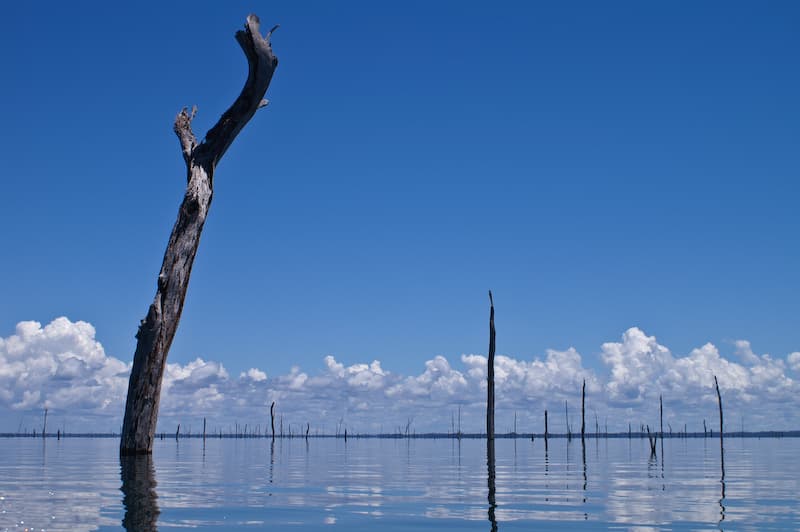
The Brokopondostuwmeer, officially the Prof. dr. ir. W. J. van Blommesteinmeer, is Suriname’s large artificial reservoir in Brokopondo District. It was created after construction of the Afobaka Dam and flooding of a large rainforest area; the reservoir now supports hydropower, fishing, transport, tourism, and nearby communities. Large reservoir with shoreline communities, forested islands and boat excursions. Use a named departure landing and a competent local boat operator. Address / area: Brokopondo district
Local rules
Road and boat access The usual access sequence is: -Travel by road toward Brokopondo District. -Continue to an approved launch point such as Afobaka, Klaaskreek, or another locally authorized landing. -Hire a local boat operator who knows the reservoir, channels, dead-tree fields, islands, weather, and lake-level conditions. -Confirm the destination, return time, fuel reserve, passenger capacity, and emergency plan. Do not launch from private, mining, utility, village, or concession land without permission. The reservoir contains extensive submerged forest, making navigation hazardous for unfamiliar operators. Air access Afobakka Airstrip, SMAF, is near the Afobaka area, not on the reservoir itself. It should not be assumed to provide passenger service, fuel, lighting, customs, emergency response, or permanent staffing. Obtain current AIP information and NOTAMs from AIS/CADSUR before using it. Independent visits Use a licensed or experienced local boat operator, lodge, or guide with community connections. Independent visitors should not simply arrive at a village, island, mining area, or private lodge without prior arrangement. Access may depend on local community decisions, land ownership, concession boundaries, weather, reservoir levels, and the purpose of the visit. Local rules and access protocols No single publicly available rulebook covers every part of the reservoir. Requirements vary by location and activity. Community protocol -Contact the relevant village captain, traditional authority, lodge, or local guide before entering community-managed areas. -Explain your name, purpose, group size, dates, boat, equipment, photography, research, and intended route. -Ask permission before entering villages, islands, camps, hunting areas, sacred sites, burial places, or community land. -Obtain consent before interviewing, filming, photographing, mapping, or using drones. -Respect local decisions, ceremonies, privacy, quiet hours, and restricted areas. -Do not remove artefacts, plants, wildlife, timber, fishing gear, or cultural objects. -Do not share sensitive location information about communities or cultural sites without permission. Boating rules and safety -Use a seaworthy boat and an experienced local captain. -Carry one approved life jacket for every passenger. -Do not overload the boat. -Carry sufficient reserve fuel for delays and detours. -Avoid high-speed travel near swimmers, fishing boats, shore camps, islands, and submerged trees. -Do not travel at night unless the operator has suitable navigation lights, equipment, local knowledge, and authorization. -Check weather and lake conditions before departure. -Keep all passengers seated during difficult manoeuvres. -Keep emergency communication equipment in waterproof protection. -Do not operate a boat under the influence of alcohol or drugs. Fishing Fishing rules depend on the type of fishing, location, species, equipment, and whether the activity is personal, commercial, or organized tourism. Before fishing, confirm current requirements with LVV or a local licensed operator. The Ministry may impose licence conditions, gear restrictions, protected-species rules, closed seasons, or area restrictions. Do not use poison, explosives, electricity, or unauthorized commercial nets. Follow catch limits, protected-species rules, and any community or lodge restrictions. Do not assume that an online fishing article is an official permit or legal authorization. Environmental protection -Do not dump fuel, oil, sewage, plastic, batteries, or food waste into the reservoir. -Do not cut or burn vegetation on islands. -Avoid nesting, breeding, and wildlife areas. -Do not feed wildlife. -Use biodegradable products cautiously and pack out all waste. -Keep campfires only in approved areas. -Respect national parks, nature reserves, concessions, and community-managed areas. Main hazards The Brokopondostuwmeer is scenic but operationally demanding: -Submerged tree trunks and branches can damage boats and injure swimmers. -Water levels and channels can change. -Weather can deteriorate quickly. -Mobile coverage may be unreliable. -There may be no nearby medical help. -Fuel and food may not be available after departure. -Snakes, insects, piranhas, and other wildlife can cause injuries. -Swimming outside designated areas is unsafe. -Alcohol and boating create a serious accident risk. -Flooding or poor roads can delay road evacuation.
Nearest help
The lake is remote and has no confirmed lake-wide lifeguard, coastguard, ambulance, hospital, or permanent rescue service. The nearest practical help depends on your exact location. Around Afobaka: Use 115 for police/security. Use 110 for fire or a vessel fire. Use 113 for medical emergencies. Contact the local Medical Mission post before travel. Use Afobaka as the primary staging point for fuel, boat launch, road transport, and evacuation planning. For air evacuation, coordinate with a qualified domestic operator and confirm current SMAF status through AIS/CADSUR. Around Klaaskreek and Benastrand: -Confirm the closest local clinic and police contact before arrival. -Arrange a boat or road vehicle in advance; do not assume emergency transport will be available on demand. -For serious illness or injury, plan onward transfer toward Brokopondo and, if necessary, Paramaribo. On remote islands or fishing grounds Carry: -Satellite phone or reliable backup communications. -GPS device or offline maps. -Life jackets for every passenger. -First-aid kit and snake-bite response plan. -Drinking water and food reserve. -Extra fuel. -Waterproof documents and phone protection. -Emergency lighting. -A written passenger manifest and return time. A district emergency document warns of serious hazards in the reservoir, including submerged branches and tree stumps, snakes, piranhas, flooding, damaged roads, poor lighting, and limited services
Last verified 2026-09-16 · version 2
Confirm the exact meeting point with your operator.
- Coordinates
- 4.858364, -55.019531
- Contact
- +597 325212 · bicbrokopondo1@gmail.com
Save essential contacts before departure. Agree who checks your arrival and how to communicate if mobile reception is lost.
Safety protocols to read before you travel
A01Guided activitiesUse a guide who knows the route and explains the safety arrangements.
Choose a guide through an established operator and ask about route experience, training, equipment and emergency arrangements. Follow the safety briefing, stay with the group and do not undertake an unfamiliar activity alone. Stop when conditions become unsafe.
Version 1 · Reviewed 2026-12-15 · Source SCSD project Revised Deliverable 2 and Workshop 1 protocol guidance
A02Jungle excursionsStay on known trails, share the route and carry essential supplies.
Stay on marked or known trails, tell someone the intended route and carry water, communications and a basic first-aid kit. Avoid excursions during severe weather.
Version 2 · Reviewed 2026-12-15 · Source Rev. - DELIVERABLE 2 REPORT - Tourism Awareness&Saferty SCSD project.docx, section 3.3; draft pending TCT/PIU approval
A03Water recreation and river hazardsCheck physical hazards and fresh-water health risks before an activity.
Ask the guide about currents, rocks, water levels and safe access before any water activity. Wear suitable flotation equipment for boating. Do not dive into unfamiliar water or enter rapids to swim or bathe, and keep children under close supervision. CDC advises avoiding swimming in unchlorinated rivers, lakes and ponds in Suriname because fresh water can carry infections. A locally designated swimming spot does not establish water quality.
Version 1 · Reviewed 2026-12-15 · Source SCSD project Revised Deliverable 2 and Workshop 1 protocol guidance; https://wwwnc.cdc.gov/travel/destinations/traveler/none/suriname
A04Wildlife awarenessDo not approach or feed wildlife; report dangerous sightings.
Do not approach or feed wildlife and do not handle unknown plants or animals. Keep a safe distance and report dangerous wildlife sightings to the guide or responsible local contact.
Version 1 · Reviewed 2026-12-15 · Source Rev. - DELIVERABLE 2 REPORT - Tourism Awareness&Saferty SCSD project.docx, section 3.3; draft pending TCT/PIU approval