Airports · Upper Suriname River
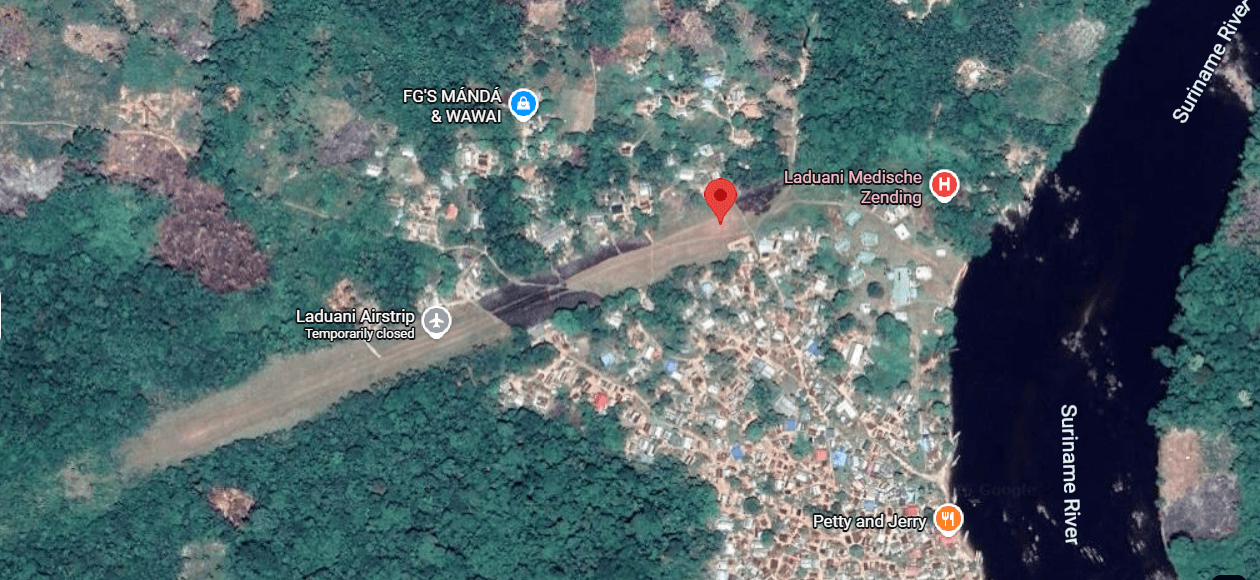
Ladouanie Airstrip
Upper Suriname River
Ladouanie Airstrip is a mapped airstrip serving the nearby Upper Suriname communities. Confirm flight operations and ground or boat transfers directly with an air operator before travel. The pin marks the general place; confirm the exact meeting point.
Local rules
Confirm the boarding point, departure arrangements and baggage instructions with your operator. Follow staff instructions. Connectivity: Save the map and important numbers before travel. Ask your operator which communication arrangements are available if mobile reception is lost. Recommended field-use procedure Before dispatching an aircraft to any non-international strip: Obtain the current Suriname AIP, NOTAMs and weather information from AIS/ATS. Contact CASAS or the Department of Civil Aviation if the flight is foreign, charter, commercial, night, VFR in controlled airspace or otherwise non-routine. Obtain written permission from the airstrip owner, community, mine, resort, government agency or private operator. Confirm runway direction, length, width, surface, slope, obstacles, flooding, animals, security, lighting and current condition. Confirm communications coverage, fuel, ground transport and a local emergency contact. Carry satellite communications, first aid, survival equipment, emergency locator equipment and a medical evacuation plan. Do not assume that a database listing means the strip is open, inspected, maintained or suitable for your aircraft. For official verification, the most important contacts are CASAS, the Department of Civil Aviation, Aeronautical Information Service, the airport operator and the local airstrip owner. CASAS maintains the applicable Surinamese aviation regulations, including CARS 012 Aerodromes, while AIS should be used for current operational information.
Nearest help
No nearest-help note is published for this location.
Last verified 2026-09-10 · version 2
Confirm the exact meeting point with your operator.
- Coordinates
- 4.377888, -55.402534
Save essential contacts before departure. Agree who checks your arrival and how to communicate if mobile reception is lost.
Safety protocols to read before you travel
A01Guided activitiesUse a guide who knows the route and explains the safety arrangements.
Choose a guide through an established operator and ask about route experience, training, equipment and emergency arrangements. Follow the safety briefing, stay with the group and do not undertake an unfamiliar activity alone. Stop when conditions become unsafe.
Version 1 · Reviewed 2026-12-15 · Source SCSD project Revised Deliverable 2 and Workshop 1 protocol guidance
A02Jungle excursionsStay on known trails, share the route and carry essential supplies.
Stay on marked or known trails, tell someone the intended route and carry water, communications and a basic first-aid kit. Avoid excursions during severe weather.
Version 2 · Reviewed 2026-12-15 · Source Rev. - DELIVERABLE 2 REPORT - Tourism Awareness&Saferty SCSD project.docx, section 3.3; draft pending TCT/PIU approval
A03Water recreation and river hazardsCheck physical hazards and fresh-water health risks before an activity.
Ask the guide about currents, rocks, water levels and safe access before any water activity. Wear suitable flotation equipment for boating. Do not dive into unfamiliar water or enter rapids to swim or bathe, and keep children under close supervision. CDC advises avoiding swimming in unchlorinated rivers, lakes and ponds in Suriname because fresh water can carry infections. A locally designated swimming spot does not establish water quality.
Version 1 · Reviewed 2026-12-15 · Source SCSD project Revised Deliverable 2 and Workshop 1 protocol guidance; https://wwwnc.cdc.gov/travel/destinations/traveler/none/suriname
A04Wildlife awarenessDo not approach or feed wildlife; report dangerous sightings.
Do not approach or feed wildlife and do not handle unknown plants or animals. Keep a safe distance and report dangerous wildlife sightings to the guide or responsible local contact.
Version 1 · Reviewed 2026-12-15 · Source Rev. - DELIVERABLE 2 REPORT - Tourism Awareness&Saferty SCSD project.docx, section 3.3; draft pending TCT/PIU approval